Split Ground Points
![]()
This command allows you to extract the terrain from a point cloud, by creating a point cloud based on the ground points without vegetation or buildings.
Select the point clouds corresponding to the ground and launch the command.
|
|
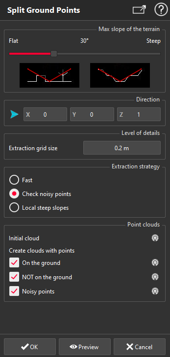
Slope of the terrain If the project concerns a rather flat urban area, the cursor can be put to the left, in order to choose a small angle for the general slope. Direction For a typical DTM (Digital Terrain Model), the direction to use would always be the Z axis, as the ground is mainly horizontal. However, another direction can be used if this function is used for example to clean the point cloud of a vertical wall and remove all vegetation points. In more complex projects where a direction cannot be found easily, it is useful to use the option Best Plane, as it will take the normal direction of the best plane of the point cloud. Level of details The average distance between points is computed by default to suit the point cloud selected. It can of course be modified to adjust the value to the needs of the project. A low value will produce a result with more points, so more details. In this case the computation will also be longer. Extraction strategy Choose the Fast extraction strategy if your data is fairly smooth. The option Check noisy points should be used otherwise. The last option (Local steep slopes) should be used in case of a terrain with locally some steep slopes (ditches for example). Point clouds This option allows you to categorize the points of the initial point cloud and export them into your project. The points will be sorted into 3 categories according to LAS format specifications: Ground, Unclassified, Noisy points. |