
This command creates a regular sampled point cloud thanks to another point cloud and a grid.
Select a point cloud and launch the command.
Note
Depending on the grid and the point cloud, the computation could be long due to the amount of points to create.
|
|
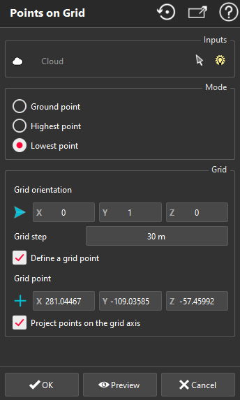
Choose the extraction Mode. You have the following choices:
Ground point: it will create points laying onto the ground of your point cloud
Highest point: it will create points corresponding to the highest area of your point cloud (in the direction perpendicular to the grid)
Lowest point: it will create points corresponding to the lowest area of you point cloud points (in the direction perpendicular to the grid)
Define the Grid parameters:
Define the Grid orientation (always in an horizontal plane)
Enter the Grid step
You can also Define a grid point i.e. a point where an intersection of the grid is supposed to be.
-
Highest-Lowest Point extraction
Each point is extracted inside an infinite cylinder with a radius equal to grid step / 10 and respect the constraint of the chosen mode.
Check Project points on the grid axis to keep a regular grid.
Click Preview to display the resulting cloud, OK to validate or Cancel to exit.
|